


Tokyo Rail Map
Tokyo Rail Map ၏ ရွင္းလင္းခ်က္
Rail & Subway Map is a clear and concise route map that features:
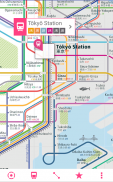
THE MOST BEAUTIFUL RAIL MAP - representing the state of the art in information design.
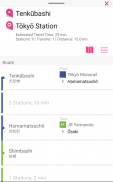
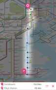
ROUTE PLANNER - instantly finds the fastest route and displays it on the map including transfer stations.
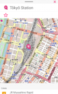
STATIONS INDEX - quickly jump to any station.
LINES OVERVIEW - shows the order of stations on each line with transit options.
GPS SUPPORT - find the station closest to you.
HIGH RESOLUTION GRAPHICS - looks stunning on all displays.
ROTATE and ZOOM - hold your device any way you want.
LARGE MAP - includes the most important stations
STATION LOOKUP - search for a station by name
OSM INTEGRATION - lookup directly from with Open Street Map
ရထားလမ်း & မြေအောက်ရထားမြေပုံတပ်ဆင်ထားကြောင်းရှင်းရှင်းလင်းလင်းနဲ့စုံစုံလမ်းကြောင်းမြေပုံဖြစ်ပါသည်:
အလှဆုံးရထားလမ်းမြေပုံ - သတင်းအချက်အလက်ဒီဇိုင်းအတွက်အနုပညာပြည်နယ်ကိုယ်စားပြု။
ROUTE Planner - ချက်ချင်းအမြန်ဆုံးလမ်းကြောင်းတွေ့ခြင်းနှင့်လွှဲပြောင်းဘူတာအပါအဝင်မြေပုံပေါ်မှာဖော်ပြပေးမှာဖြစ်ပါတယ်။
ဘူတာရုံ INDEX - လျင်မြန်စွာဆိုဘူတာမှခုန်။
Line ခြုံငုံသုံးသပ်ရန် - အကူးအပြောင်းအတွက်ရွေးချယ်စရာများနှင့်အတူအသီးအသီးလိုင်းပေါ်ဘူတာ၏အမိန့်ကိုပြသထားတယ်။
ဂျီပီအက်စ်ပံ့ပိုးမှုစင်တာ - ဘူတာရုံသငျသညျအနီးဆုံးရှာပါ။
high resolution graphics - အားလုံး display တွေအပေါ်ရင်သပ်ရှုမောဖွယ်ကြည့်ပါတယ်။
လှည့်နဲ့ zoom - သင့်စက်ကိုသင်လိုချင်တာမဆိုလမ်းကိုင်ထားပါ။
မြေပုံကြီးကို - အရေးကြီးဆုံးဘူတာပါဝင်သည်
STATION ကို lookup - နာမတော်အားဖြင့်တစ်ဘူတာအဘို့အရှာဖွေရေး
OSM ပူးပေါင်းခြင်း - ပွင့်လင်း Street, မြေပုံနှင့်အတူကနေတိုက်ရိုက်ကြည့်ရန်
Tokyo Rail Map - ဗားရွင္း 1.6
(07-09-2020)Tokyo Rail Map - APK သတင္းအခ်က္အလက္
APK ဗားရွင္း: 1.6package: com.urbanmap.tokyoTokyo Rail Map ၏ ေနာက္ဆုံးဗားရွင္း
အျခား ဗားရွင္းမ်ား


က႑တူအက္ပ္မ်ား

သင္ႏွစ္သက္ႏိုင္သည္မ်ားမွာ...


